

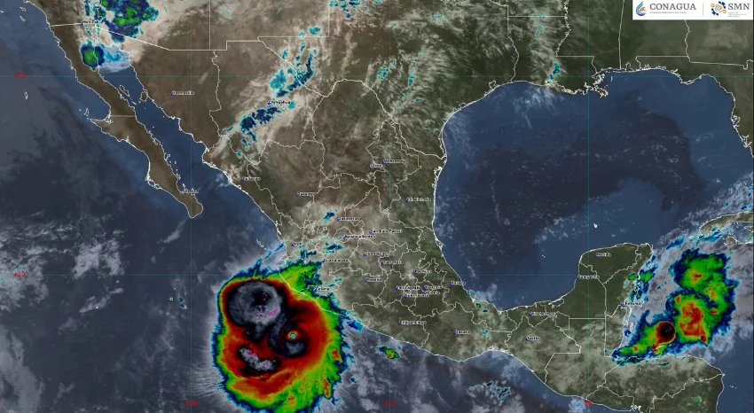
Hurricane Polo is currently impacting several states along Mexico’s Pacific coast, presenting a serious risk of heavy rainfall, strong winds, and dangerous surf conditions. The National Meteorological Service (SMN) has flagged the potential for intense rainfall in the western and southern parts of the country, which could affect daily life, especially for families and businesses in coastal areas.
As of Thursday morning, Polo maintains winds nearing 160 mph and is situated about 245 kilometers south of Manzanillo, Colima. The SMN has specifically pointed out that Colima, Jalisco, Michoacán, and Guerrero face the highest likelihood of severe weather, including torrential downpours that could reach between 150 to 250 millimeters.
Residents of Tecpan de Galeana in Guerrero, extending north to Manzanillo, are warned that tropical storm conditions are anticipated. Although Hurricane Polo is expected to gradually move out to sea, it remains a significant threat due to its core’s proximity to coastal communities.
Hurricane Polo has made headlines for its rapid intensification, rising from a tropical depression to a Category 5 hurricane in a historic time frame. This transition sets a record for the fastest change of its kind in the Western Hemisphere. The storm has fluctuated between Categories 4 and 5, retaining the potential for further strengthening as it moves toward the Baja California Peninsula.
Experts assert that the hurricane’s unusually warm core ties this storm to other record-setting hurricanes like Rita in 2005. This highlights the extraordinary nature of Polo, which surpasses many intense weather systems previously recorded in the Pacific.
Citizens are encouraged to stay informed through the Government of Mexico and local authorities for guidance on safety measures to protect themselves and their property amid this extreme weather event.